|
[back]
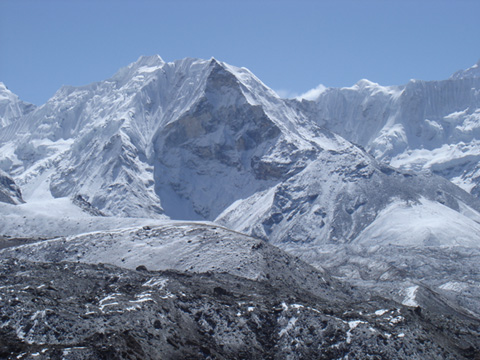
Island peak from W
Island Peak (Imja Tse) 6156m
One of the most
famous trekking peaks in Nepal. The peak is embedded in a great and wild scenery,
with impressive views towards the Lhotse S-face and towards the Baruntse group.
The summit is particularly popular due to its easy reachability and the
comparatively easy ascent from south. However, it is still a very alpine climb
which requires good physical conditions and basic ice knowledge of the climbers.
______________________________________________________________________
|
From Imja
Tsho lake via the south face
Normal route. Very often attempted. It is a particulary long climb if done in one day,
however,
there is the possibility for a high camp at about 5400m. The lower part of
the ascent is mostly over alpine meadows and scree, which can be tiring.
The upper part consists of a short glacier crossing, followed by a steep
(45°) snow and ice face of about 80m height. A short but exposed ridge
leads to the summit. There are usually fixed ropes on the face and the
ridge. Beware of falling ice in the face if there are other people.
The climb is comparable to easier 4000m peak normal ways in the alps, for
example the Gross Fiescherhorn in the Bernese Alps. Experiences climbers
will climb the face and the ridge without rope, however, be aware of
crevasses on the glacier. |
PD+
(alpine style)
|
7 hours from
the Island peak base camp at 5100m, 10 hours from Chukung.
Images at the bottom of this page. |
|
From the base
camp, 5100m, follow for about 10min the track towards E, then climb the
steep debris-covered meadows on a good path. At about 5400m, you reach the
high camp which basically consists of some small terraces where one can
put up a tent, 2h.
Now a broad couloir comes down from the glacier. Head towards the left (W)
side of the couloir and climb it for about 100m. Then the traces traverse
the couloir (minor danger of ice fall) and continue on the right side. Go
across a shallow ridge, reaching a large scree cauldron (E of the couloir).
Follow the traces that head up, reaching a small ridge. Traverse the ridge,
reaching the glacier at about 5820m, 4h. Note: Other variants are more
difficult and subject to rock and ice fall.
On the glacier, first to up for some minutes, then head to the left (W),
avoiding some crevasses. Then head directly towards the S face, 5.5h.
Depending on the snow conditions, the face is either climbed on the left
(E) where it is less high and less steep, or on the right (higher and a
bit steeper). The face consists of snow or ice. Usually there are steps in
the ice from previous climbs, 6.5h.
The ridge is then directly climbed, the first steep section is best
avoided on the S side. 7h from the base camp to the summit. |
______________________________________________________________________
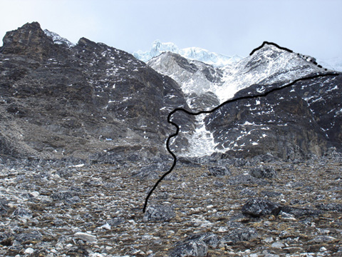
Lower south face of Island peak.
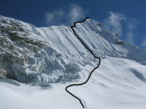
Upper south face of Island peak.
|